Drone Aerial & Orthophoto
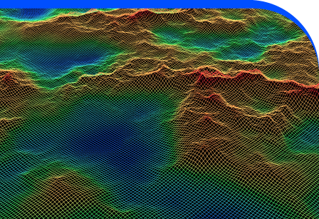
Drone Aerial and Orthophoto surveys provide detailed, high-resolution imagery that captures the complete picture of your site from above. By combining drone technology with advanced processing software, we deliver orthophotos, roof models, terrain imaging, and digital surface models (DSMs) that bring clarity to planning, monitoring, and development. These outputs are more than just pictures, they are spatially accurate, scaled datasets that allow you to measure, map, and visualise landscapes with precision. Our aerial surveys support topographic overviews, construction progress checks, roof condition assessments, and environmental monitoring, saving time compared to traditional methods. With drones, large areas can be captured quickly and efficiently, providing up-to-date site information that is easy to interpret and share with stakeholders. Whether you’re planning a development, managing land, or inspecting assets, drone orthophotography gives you accurate, accessible data for informed decisions and confident project delivery.
Visualising Projects With Aerial Perspectives
Our drone surveys transform site management with scaled orthophotos and 3D DSMs. These visual datasets provide measurable accuracy for planning, construction, and land assessment. Capturing rooftops, terrain, and landscape features from above offers unrivalled clarity, ensuring every project benefits from fast, efficient, and cost-effective survey data that supports better communication, decision-making, and progress reporting.


Smarter Project Overviews
Aerial surveys offer unique advantages over ground-based methods. They provide broader coverage, quicker turnaround, and clear visual insights for stakeholders. Orthophotos and DSMs allow accurate measurement, condition monitoring, and progress validation. This makes drone surveys essential for projects where time, detail, and reliable data all drive better outcomes.
Fast Capture
Accurate Data
Clear Visuals
Adding 360° Vitual Tours To Survey Deliverables
Blueprint Surveys now integrates Blueprint360View technology into its survey outputs, offering clients the option of 360° virtual tours alongside traditional deliverables. This enhancement transforms measured data into interactive digital environments, helping architects, planners, and developers visualise projects with clarity. The combination of precision surveys and immersive visuals accelerates decisions, improves communication, and strengthens project presentation